

The early settlement of Twofold Bay, as described
in some early short history publications,
give the impression that there was no human
habitation or none of any importance in the
area before the whiteman arrived. It was
as if by divine right that the land was empty
and ready for white settlement. Of course,
that was not the case.
The Aboriginal tribes of the far south coast
of New South Wales lived a life of rich cultural
and hunting traditions that fed their families
with sea food and land mammals. Huge middens
built up over thousands of years along the
banks of the Pambula River show a life of
plenty. What a life it must have been, living
off the ocean and rivers, walking up to the
Monaro regions for the Bogong moth season
and along the way coastal and inland tribes
meeting on the banks of the Towamba River
to pass on news, carry on men and women's
business, meet new members and future partners
and to hold corroborees on the river flat.
The early settlers experienced this spectacle
not realising they were watching something,
in some cases, never before seen by whiteman.
They were, perhaps, unknowingly privileged
as over the next fifty years or so the lives
and culture of the Aborigine in this area
changed forever and, in some cases, tribes
were purposefully tracked and hunted until
little of their traditional way of life remained.
From Granny McCarthy's bible.
"William McCarthy born in London, March
17, 1820. His wife, Jean Craigie, born Strathaven,
Scotland, January 2, (no year stated) married
at Boydtown May 4, 1848. Eldest son born
at Eden 27 March, 1849."
"My mother born at Towamba December
5, 1850. Our grandfather was in charge of
Towamba (Station) for Ben Boyd, as head stockman.
We believe it was the only house there then,
the remains of their old cottage was across
the river opposite Bollman's. Old fruit trees
there in our time in Towamba.
What lonely times for young folk from Sydney.
Grannie often told us of the wild Blacks
from the tablelands meeting the coastal tribes
and holding corroborees on the flats where
Bollman's farm was in our time. Grannie sat
up all night and watched them while Grandfather
was away with cattle to Boydtown, all the
company she had was a tame Black Gin. Grannie,
only 18 when she married."
Source: Excerpt from a letter. Mrs. J. G.
Stevenson writing to Mr. Bert Egan (former
curator of Eden Killer Whale Museum) in 1958.
December 15, 1858
'The Goulburn Herald and County of Argyle
Advertiser'
ABORIGINAL BURIAL.- On a visit to East Boyd, on Saturday last,
I was much struck with the care the aboriginals
exercise in the burial of their dead, and
their apparent regrets at the loss of one
of their tribe. The King of Kiah and his
cousin were engaged digging the grave, on
the beach within a few yards from the sea,
for the reception of their sister and cousin,
and not a syllable escaped from the lips
of those poor and unfortunate sons of toil,
with the tear in their eyes, and perspiration
on their brows, until the bark had been laid
at the bottom of the grave, with a few extra
strips at the head to form a pillow, and
the body, which was wrapped in bark, had
been consigned to its resting place, and
covered with sand, in which a few evergreens
were carelessly strewed, then the faithful
old king, generally known as Jeremy Taylor,
gave vent to his grief, and his companion
joined him. December 7, 1858.
KATE. Were there any Aborigines out there when
you were there?
HAROLD. Not when I was there. No.
KATE. Was there a bit of a dark history with 'Nangutta'?
HAROLD. Well, Jack Brindle.....Jack Brindle's
mother was supposed to've been a black. She'd
'sposed to've reared him in what they call
a 'wee wong'.
KATE. Who was Jack Brindle?
HAROLD. He was a stockman on 'Nangutta Station'.
There was a paddock they called 'Brindle's
and there was a hut there called 'Brindle's
hut'. But he died here, I think, up in Bombala.
He told someone he was going to die and he
just died.
Excerpt from 'The Forgotten Corner Interviews'
Harold Farrell Interview, compiled by Kate
Clery.
Judy Winters, in her paper 'Nungatta South',
states that: "For centuries before whiteman
ventured into the wild unexplored ranges
of the far south eastern corner of NSW and
the north east of what was to later become
the State of Victoria, those lands were the
territory of the Australian Aborigine. .....it
was not until the Squatters moved into the
hitherto unoccupied lands and came into contact
with the Aborigines that their part in the
european history of this area takes place.
Excerpt from 'Nungatta South' by Judy Winters
Throughout Australia, contact with the white
man, has involved the extinction of the arboriginal,
and unfortunately the tribes of Manaro seem
to have been no exception to this rule.
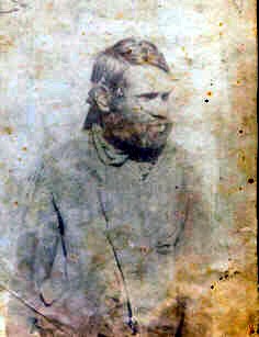 |
| Notation on the reverse of the photo looks like: "Biggenhook, Nimitybelle, 1902. Taken by Sen(r?) Cous Barnes, Nimitybelle." Photo courtesy Megan Monaro |
Years ago hundreds of them would come in
and about the towns to share in the annual
distribution of blankets. To-day, and for
a number of years past one might search Manaro,
and fail to find a full-blooded native. The
last of these in Cooma was one known throughout
the district as "Biggenhook." He
was a son of Bony Jack, and though deaf and
dumb from birth, was extraordinarily intelligent.
A good bushman and stockman, he attached
himself to the family of Wallace, who at
one time held Coolringdon, and though he
would stay with them for months, the longing
to get away would come upon him, and he would,
without any explanation, go away to another
part of the district where he knew he was
welcome. He made himself understood almost
entirely by signs erked out by sketches in
the dirt. His sign language was extraordinarily
descriptive, and he picked out, with uncanny
accuracy, any physical peculiarity of an
individual, wherewith to describe him. He
indicated cattle, sheep and horses, by drawing
their brands, and in this way could give
information of stock owners and stock movements.
After the Wallace family left the District,
he attached himself to the writer, who was
able to understand him, and thus had many
opportunities of gauging in him, what it
is asserted the Australian Aboriginal does
not possess high degree of intellectuality.
Biggenhook who except during the last three
or four years of his life, preserved his
extraordinary activity, died at about the
age of 62 some ten years ago.
But little information is obtainable as to
the meaning of the native words which are
to-day used to designate stations or localities.
Some which have been gathered are appended:
Adamindumee (now Adaminaby) - Camping or
Resting Place.
Boonyan (now Bunyan) -Pigeons' Resting Place.
Chakola (formerly Umeralla) - Place for Lvre
Birds.
Cooma or Coombah - Big Lake or Open Country.
Coobon (now Cobbin) - Much: plenty.
Cootapatamba - Place where the Eagles Drink.
Coolmatongah - Running Water.
Maneroo - Plains.
Jillamatong - One Hill.
Nijong - Water.
Nimmitabel-The starting place of many waters.
Matong-Strong.
Ironmungie - Plenty Ants.
Jimen Buen - Big Fat Kangaroo Rat.
Gejizrick - Look Out.
Wullwah Woolway -Camp.
Marrinumbla - Plenty Flour.
In some of these names the recurrence of
the syllable "ma" is of interest
in connection with the spelling of the name
"Manaro."
Transcribed from "BACK TO COOMA"
Felix Mitchell 1926 pp34-35 by Pattrick Mould
2002
The excerpt below is taken from:
'Bega Valley Region Old Path Ways and Trails
Mapping Project' by John Blay 2005 (with kind permission)
SUMMARY
There were important path ways throughout
the region. Some used mountain passes to
go to the Monaro and High Country of the
Australian Alps. These were used for thousands
of years by the coast Aboriginal people to
go to the Bogong ceremonies in the mountains,
just as the inland people went to the coast
for events like the whale ceremonies. Substantial
parts of these ways still exist in wild country,
in National Parks and State Forests.
It is of great significance that you can
still walk from the highest part of the country
to the coast through relatively natural surroundings
following path ways used traditionally for
millennia. The distance is generally less
than 250 kilometres. Considerable parts of
some east - west ways are today away from
made roads, the remainder along trails and
minor country roads that have essentially
followed the routes of the old ways.
The main north - south ways are for the most
part today followed by main roads.
A map of the Bega Valley Region Historic
Path Ways and Trails has been compiled from
old maps and journals and cultural sources
to show the major ways.
The Koori people of this region recognise
they have a remarkable history and believe
this should be acknowledged along with the
more recent shared history. They say many
of their practices are remarkable and unique,
even in a world context. Some stuff has to
be kept private, but the general stories
should be recognised through all levels of
community. They can give the region a stronger
focus and character, just as for example
the unique character of the desert people
gives central Australia its renowned world-wide
reputation.
This area includes Yuin, Ngarigo and Bidawal
country. Things were different here. The
people had their own ways and designs. Their
stories illuminate humanity's relationship
with nature. Where else in the world were
there gatherings like those for the Bogongs?
Where else anything like the association
with Orcas and whale hunting in Twofold Bay?
The old ways are symbolically important to
Kooris of the region because they reinforce
the connections that have always existed.
Their official recognition would apparently
help break down the sense of loss and isolation
that comes where people have of necessity
to live at some distance from their own country,
and lend weight to cultural renewal.
In short, the more the historical sources
are researched the more the ways become certain.
Similarly, the more they are investigated
on the ground, the more evidence is discovered.
Therefore it is recommended a Koori-managed
project extending from the coast to the Monaro
and High Country be undertaken to investigate
the connections more, both on the ground
and in further research, especially in relation
to sites and biodiversity. It is vital to
conserve, preserve and manage what still
remains, as some parts are regarded as sensitive
to disturbance.
It is also recommended that parts of some
ways be protected, while others could be
appropriately developed for public use, education
and enjoyment. The full potential of these
ways in cultural and tourist terms is yet
to be assessed, but in greater regional terms
there are some corridors that could well
deserve the highest heritage status.
An historian's view of path ways.
In his book, 'Looking for Blackfellas Point', Mark Mckenna, 2002, puts some of the issues most eloquently:
"Why, it was the blacks, and nobody
else, who opened up the country," he
said. "Who else would have opened it up? ... They led you
and me and everyone else here and there"
... "The blacks ... would yabber about a big fellow
station out there and the settlers, desirous
of
increasing their territorial possessions,
would ... go after them". (District
of Monaro Newspaper cuttings, Mitchell Library Q991/N vol. 44
(most probably 1890s);)
![]()
![]()
![]()
![]() LINK
LINK![]()
![]()
![]()
 |
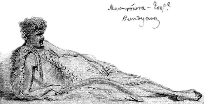 |
| At his ease. This princely inhabitant of Bundyang wearing a possum skin cloak was drawn by OW Brierly in about 1843. |
STEP BY STEP THE BUNDIAN WAY DREAM IS REALISED
The Magnet
Thursday, December 6, 2012-12-28
(Excerpt from article)
An excited crowd of well over 100 people
gathered for the launch of the Bundian Way
Gallery in Delegate on Saturday, with many
others coming along to enjoy the art on exhibit
over the entire weekend.
The opening proved a colourful event with
visitors from all over the region, including
a number from Canberra.
A good contingent of Kooris from Eden came
up to the celebrations, led by BJ Cruse of
Eden Local Aboriginal Land Council who provided
the welcome to country. He described the
importance of kinship to the Aboriginal people
and how their totems provided relationships
or connected people from one country to another.
John Blay, on behalf of the Bundian Way Project,
thanked the Delegate Progress Association
for their remarkable efforts in making the
Bundian Way Art Gallery a reality. He noted
there is still a long way to go before the
Bundian Way can be officially opened, and
that it is necessary to find the cooperation
of all levels of Government as well as the
community.
"Today is one step along the way,"
Mr. Blay said.
Towamba author and historian Mark McKenna,
who won the Prime Minister's Literary Award
fro non-fiction earlier this year, spoke
passionately about the importance of history
and recognition of the Aboriginal people's
role in managing the landscape we view today.
"That's one reason why the Bundian Way
and the opening of this gallery this afternoon
are so important. For many non-Aboriginal
Australians, Aboriginal art is something
they think comes mostly from the north of
our country," Mr. McKenna said.
ANCIENT PATHWAY HERITAGE LISTED
The Magnet,
Thursday, December 27, 2012
An ancient Aboriginal pathway linking the
high country of Mount Kosciusko with Twofold
Bay has become the first Aboriginal pathway,
and the longest pathway yet, to be listed
on the State Heritage Register.
The 265km-long Bundian Way remains relatively
unchanged since colonisation and passes through
Snowy River country, the treeless plains
of southern Monaro, the south-east forest
and the coastal ranges.
The Eden Local Aboriginal Land Council has
been working to conserve the path and prepare
it for cultural activities for around 10
years.
In particular Eden Koori elder BJ Cruse and
historian John Blay have used surveyors'
notes, explorer's diaries dating back to
1851, interviews with Aboriginal people and
a thorough survey of the actual path itself
which was undertaken in 2010 and 2011.
Mr. Blay said the heritage listing was a
great step forward for the project and complimented
an award received for outstanding contribution
to heritage conservation in New South Wales
on Tuesday, December 11.
"It's been really essential to have
this kind of support, it's been a huge process
to get this rolling because the pathway is
just so big," he said.
He said the two main areas of focus now are
to develop signage and link the path to Eden.
"One of the things we are trying to
do now is work out a signage strategy and
interpretations for the Bundian way so all
the information we put to the public looks
the same," he said.
"What we hope to do is connect Eden
to Bilgalera (Fisheries Beach) and we hope
to put in interpretations along the way there
too, it's a gorgeous walk, and there are
middens and other historic sites there."
Andrew Constance Member for Bega said he
is very pleased to assist the ELALC in the
Bundian way project. "People walked
the Bundian pathway not just to attend a
corroboree or gathering, or to access a particular
food supply, but for practical, ceremonial
and educational purposes including maintaining
kinship ties, conducting business and trade,
sharing knowledge and resources and making
alliances and settling disputes," he
said.
"In summer in the high country, Aboriginal
people feasted on the migrating Bogong moth,
while in the spring, they would travel to
the coast to attend whale gatherings at Bilgalera
(Fisheries Beach)."
"It was shared with settlers and explorers
and made settlement of the far south coast
possible," Mr. Constance said.
The Bundian Way project also includes the
development of sustainable camping sites
and guided tours.
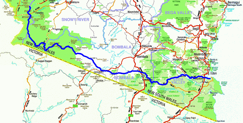 |
| The Bundian Way marked out in blue |
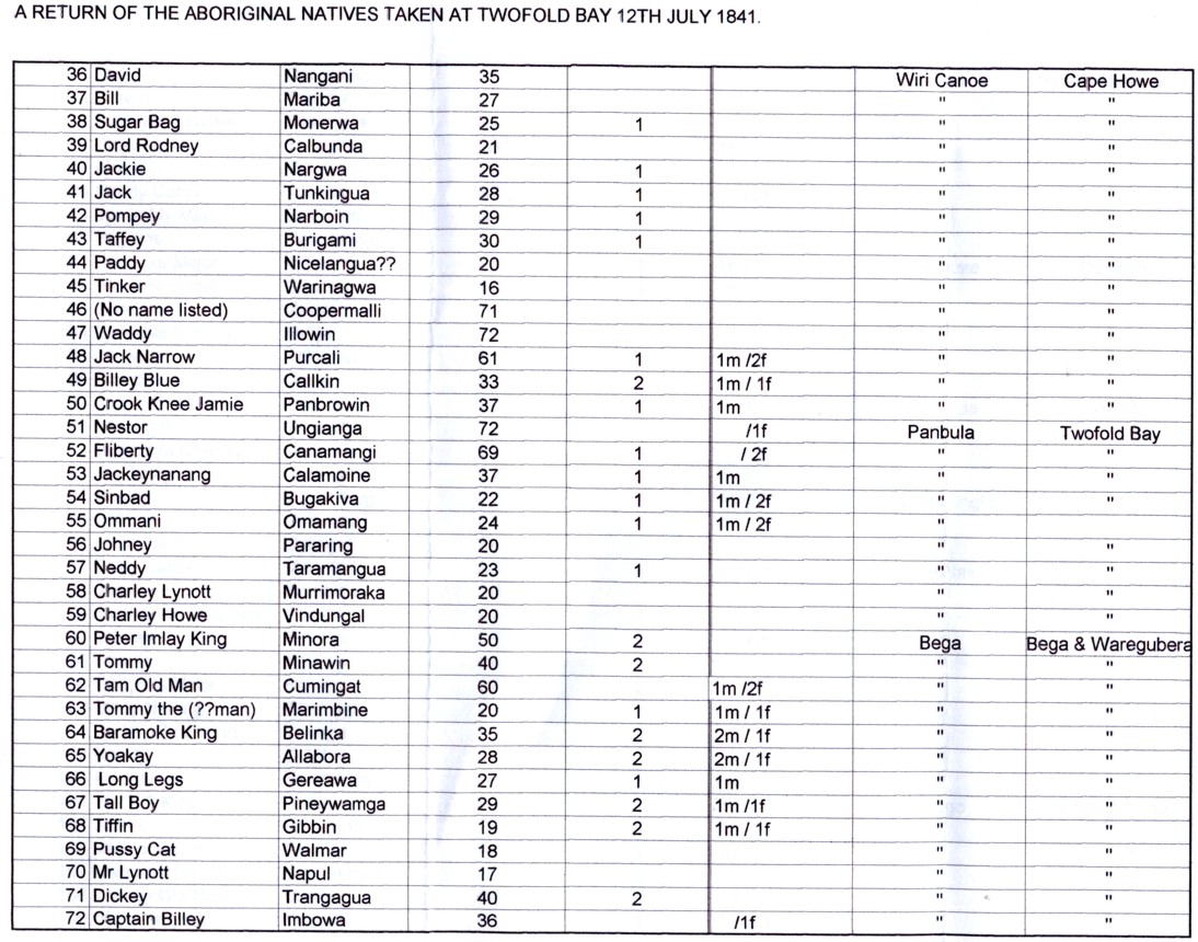
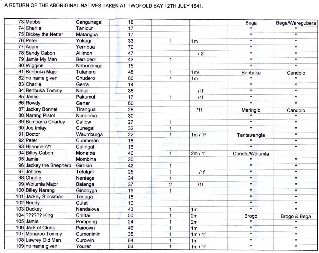
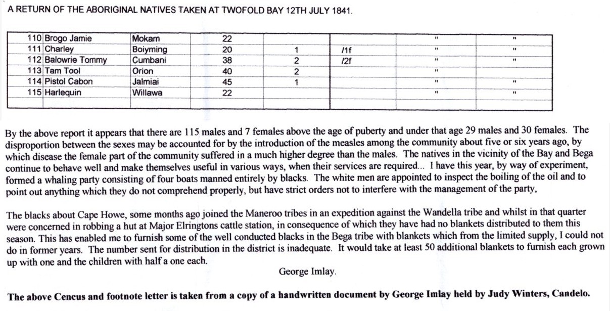
The charts below are courtesy of Judy Winters
 |
 |
 |
 |
![]()